Table of Contents
Introduction
Louis Armstrong famously crooned “I see skies of blue, and clouds of white…” But we know that clouds aren’t always white.
We use the term “cloud opacity” to refer to the grayness (or brightness) of a cloud. A cloud looks white when light moves through it with little interference, and it looks darker when the droplets or ice particles scatter or absorb more of that light. In practical terms, opacity describes how densely packed the cloud droplets are and how strongly they interact with sunlight.
This post describes some simple observations I made in the days leading up to Thanksgiving 2025 and how they may provide evidence for a shift not only in the clouds, but also in how the atmosphere as a whole may have recently been reorganized.
Climate Shift Context
Since late November, weather patterns seem to have lost some of their predictability. The jet stream has dipped sharply over eastern North America while in Europe regions of warm and cold air slide north and south with more ease than usual. Forecasters are concerned about “uncertainty in the long-range forecast”, and perhaps a bit more so than normal.
All of this anomalous behavior might be an indication that something completely unexpected may be happening in the climate system. It appears that the entire Earth system may be undergoing a regime change: a rapid shift from one way of behaving to another. And perhaps more surprisingly, the story I’ve managed to pull together suggests that the climate shift has already happened. This post is the first of several that aim to detail this shift.
Cloud Observations Didn’t Add Up
Seeing quite a bit of confusion over the evolution of the weather patterns on my Facebook feed got my brain going. When I really need to think about the atmosphere, I walk out to my driveway to check out the clouds. On Sunday, November 23, the clouds looked different.
Below, I share a photo from an unknown date and unknown location that illustrates some of the features I typically see. As I describe what I saw, you can refer back to this photo and mentally note the differences that I describe.

Source: Wikipedia
Darker Than Usual
In the photo above, the clouds are white on their tops and sides, and they are dark along their bases. Usually, the tops and sides of clouds contain a dense field of small liquid droplets. As sunlight travels through the top of a cloud, it is redirected many, many times. The light that emerges from the cloud radiates outward in all directions and in nearly equal proportions across the colors of the rainbow. The colors blend, and the cloud appears white.
While the tops and sides of clouds are usually white, the lower regions of clouds contain more liquid water and their droplets tend to be larger and more uniform in size. In these darker regions, direct sunlight is less able to penetrate downward through the cloud into the interior of the dark region. As a result, less light emerges from the cloud and reaches your eyes. Yet it still radiates outward in all directions and equally across the rainbow. As a result, we see the bottoms of clouds as gray.
In contrast to the clouds I usually see that are dark only on the bottom, the clouds that I observed on Sunday, November 23rd were uniformly gray throughout. That is, the cloud opacity was uniformly low. Unfortunately, I didn’t think take a photo of those cumulus clouds in their total grayness.
New Patterns in Gray Cumulus Clouds
I had noticed some subtle anomalies the day before, but on Sunday, the cloud patterns I was seeing were new to me. The clouds were still cumulus clouds, in some ways not altogether different than in the photo above, but their opacity and the manner in which they aligned with each other were notably different.
The low-level clouds I saw on this day were spaced apart – nothing new there. The clouds’ height was about the same as normal and relatively uniform across the cloud field. However, the clouds were noticeably wider than usual. Their aspect ratio struck me as different: they looked too squat. There was also much more variability in their widths than I usually see.
The alignment of the clouds with each other also defied the patterns I’m familiar with. The spacing between cumulus clouds often appears random, but these clouds looked like they were haltingly trying to organize. The cumulus clouds were arrayed in a line, but this alignment wasn’t neat. The centers of the clouds were much more misaligned than usual, as though their supporting circulations were less synchronized. Furthermore, the axis of greatest width was perpendicular to the orientation of the line. It was as if the plumbing that was supporting the cloud structures was causing the clouds to pop up in different places.
As I tried to make sense of what I was seeing, just enough seemed different about the proportions of the height, width, spacing, alignment, and opacity of the clouds that I sensed something didn’t line up with my expectations…or with anything I’d seen before. By the time I had processed this, the clouds had disappeared. So I waited until I could get a picture.
See For Yourself
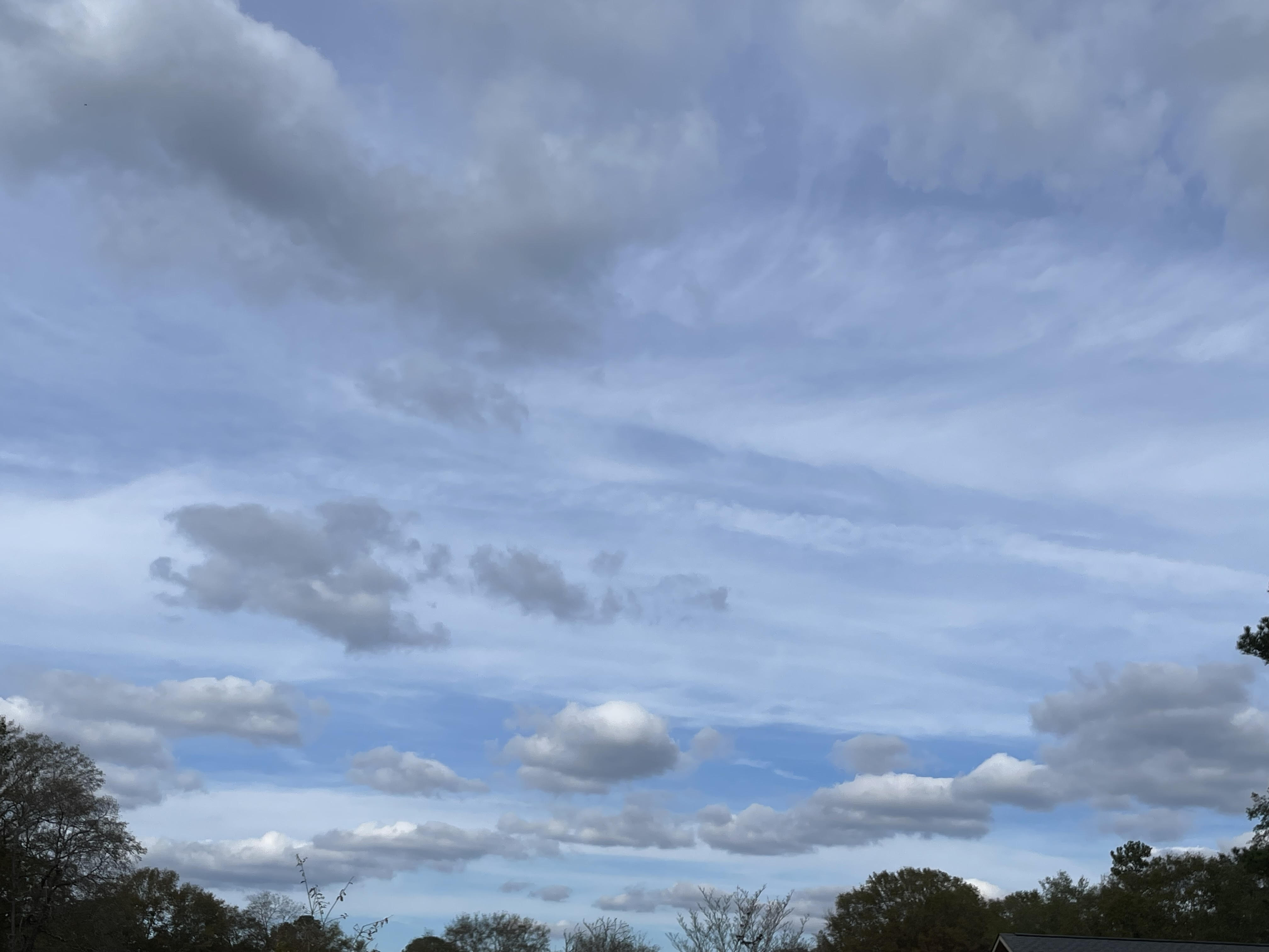
This photo was taken a few days after I noticed the all-gray clouds, on Wednesday, November 26. It exhibits many of the features I observed in the section above.

Before you read, make note of the gray and white areas on the clouds, as well as the structure of the cloud formation. Where are the clouds lightest and darkest, largest and smallest, and how do they align with one another? When you’re ready to continue, read on…
Normally, from this angle and at this time of day, clouds of this size would be mostly white, except for a small patch of gray on the their base. Compared to the photo we saw earlier, these clouds contain more gray along their sides, and become lighter toward the top. Even at their lightest, they’re not completely white.
Usually, when a cloud begins to dissipate, its droplets tend to shrink, especially at the edges of the cloud. As the smallest droplets disappear, the edges become more ragged. A cloud usually shrinks from the sides and top inward. It smallest droplets tend to occur where the evaporation is taking place, and this part of the cloud is usually wispy and white.
But go back to the photo above: notice that the elongated clouds in the top left quadrant of the photo appear jagged along their edges, as if they are evaporating. Contrary to what we’d expect, these clouds are the grayest of all! That is, they are optically thickest.
Now let’s consider the structure of these “new” clouds. Several clouds are aligned in a straight line that is oriented diagonally to the viewer. In the center of line, the smallest cloud is at the very center of the formation…and appears to be evaporating. Could it be that where clouds used to dissipate from the outside-in, they now dissipate inside-out? And if so, why is this happening?
These are, admittedly, very subtle differences. But sometimes the subtlest differences are the easiest to detect (and to make sense of). My interpretation? I have a hunch that this these changes reflect a wholesale shift that explains why weather patterns have become so unpredictable. And I’m working hard to understand what is happening.
The photos are below. The photo on the left represents the old climate regime, and the one on the right, I believe, represents a brand new climate regime that encompasses all scales, extending from these clouds to the entire globe.
As I close this post, I invite you to study the two photos, contemplate these differences, and come to your own conclusion.
Want to receive future posts related to this study in your inbox? Be sure to subscribe to this blog using the “Newsletter” link at upper right. This work is made possible by those who believe in it. Thank you for considering a gift to help ensure its continued momentum.
Author’s Note: This summary is freely available for educational use. Please cite “Jessup, S. (2025). Do Rapid Changes in Cloud Opacity and Structure Indicate an Emerging Climate Regime Shift?” in scholarly work.